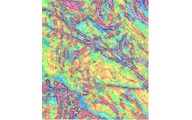
High resolution aeromagnetic maps from data acquired by a total-field magnetometer reflect the underlying geology of the survey area. Such maps are invaluable tools for explorationist's working in all kinds of environments, whether forest, mountain or desert.
Aeromagnetics & Magnetic Gradiometry

High resolution aeromagnetic or magnetic gradiometer surveys play a very important role in any exploration program. Improvements in magnetometer design and the introduction of real-time digital compensators now ensures very accurate data, which when combined with GPS, provides extremely detailed aeromagnetic and aeromagnetic derivative maps. Such highly detailed and accurate data and maps might indicate that areas that were previously flown using instrumentation and methods now considered obsolete, should be reflown and mapped.
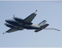
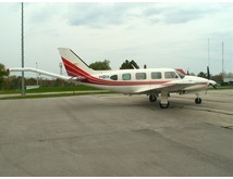
High resolution aeromagnetic or magnetic gradiometer surveying for mining exploration may be conducted using either fixed-wing airplanes or helicopters. The choice of aircraft depends largely on project size, location, budget and application. Fixed-wing and helicopter-borne aeromagnetic or magnetic gradiometer systems are designed for use in different terrains, although helicopter-borne systems are undertaking high-resolution surveys in areas traditionally the domain of fixed-wing systems.
An Overview
In a minerals exploration program, aeromagnetics or magnetic gradiometry may be used to do the following:
• Map physical properties, including magnetic susceptibility and magnetic remanence
• Map lithology, metamorphism, structure and tectonics
• Map alterations and the enhancement or depletion of magnetite
• Directly detect certain minerals, such as iron ore and pyrrhotite
• Detect magnetic massive sulphide bodies, usually nickel or gold-copper-lead-zinc deposits
• Detect kimberlite and lamproite intrusions
• Detect chrome- or PGE-bearing ultramafic rocks
• Detect tin-tungsten or rare-earths associated with granites
• Geological mapping, including:
˗ Lithologic and structural mapping in weathered or covered areas
˗ Sedimentary basin geometry and structure, mapping intrasedimentary sources
˗ Regional studies for tectonic purposes (e.g. crustal studies)
˗ Exploration for favorable ore environments
• Depth to basement mapping, including:
˗ Non-metallic mineral exploration
˗ Exploration for minerals associated with buried basement surfaces
(e.g. gold and unconformity uranium)
Drape Flying
To obtain high-resolution aeromagnetic or magnetic gradiometer data, fixed-wing survey aircrafts should be flown at a consistent height above the ground, maintaining a consistent and safe altitude (the drape surface) along the two orthogonal survey line directions. When and where appropriate, we operate a computer-assisted system, 3DNAV, to enable our flight crews to maintain an optimal flight altitude (drape surface) during surveying while at the same time ensuring that primary and control lines intersect at the same altitude. The result can be a considerable improvement in the quality of the high resolution data acquired, particularly in hilly or mountainous terrain.
Total Field or Gradiometry?
High resolution aeromagnetic maps from data acquired by a total-field magnetometer reflect the underlying geology of the survey area. Such maps are invaluable tools for explorationist’s working in all kinds of environments, whether forest, mountain or desert. They are also very important tools in the interpretation of structures and rock type distribution. Aeromagnetic surveys, whether conducted by a fixed-wing or helicopter platform, are rapid and relatively low-cost compared to other exploration techniques, which makes them very attractive as a reconnaissance tool in the early stages of an exploration project.
Gradiometer surveys can acquire very detailed, high-resolution data by flying at low altitudes and moderate speeds.
A vertical magnetic gradiometer is better at detecting near surface magnetic sources than a total-field magnetometer, making the gradient method ideal for mineral prospecting.
A horizontal gradiometer also provides detailed near-surface information, but it also interpolates data between survey flight lines, which is important if the survey target has similar dimensions to the survey line spacing.
Both vertical and horizontal gradiometers are much less affected by diurnal changes in the magnetic field than is a total-field magnetometer, so they are particularly well-suited for use in those parts of the world where significant diurnal activity may be expected.
McPHAR International can provide fixed-wing aircraft and helicopter-borne systems equipped as follow:
- Single sensor Total Field
- Two sensor Vertical Gradiometer
- Two sensor Horizontal Gradiometer
- Three sensor Horizontal Gradiometer
 |
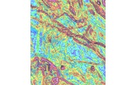 |
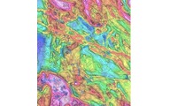
 |
| Total Magnetic Intensity Map. | Horizontal Gradient. | Vertical Gradient. |