GRAVITY
An AIRBORNE GRAVITY Survey involves the use
of a stabilised gravity meter installed on a fixedwing
aircraft, to acquire data over a given area
concerning the earth's gravity fields.
The data acquired by such a system may be used to:
- Infer the location of the thickest sedimentary section
- Delineate basin outlines and boundaries
- define plate tectonic structures
- Locate and detail map sedimentary basins for oil and gas (salt diapir identification, assisting seismic survey planning, processing and model constraint).
- Often map structures within the basin
AIRBORNE GRAVITY surveys are usually conducted in association with a magnetic survey, which provides a very reliable and relatively precise (typically 5 percent or less of the depth below the flight level) method of determining the depth of the sedimentary basin.
McPHAR'S AIRBORNE GRAVITY SYSTEM
Geological targets detectable by McPhar's airborne gravity system are in the 2- to 3-km half wavelength range. The key is to acquire and preserve amplitude and wavelength detail. Aeromagnetic and gravity data provide information about the main structural trends, including fault patterns and sedimentary basins that may contain a suitable suite of source, reservoir and seal rocks.
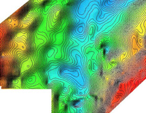
Bouguer Gravity Map from survey in South America
Wavelength resolution is limited by sampling interval and ultimately by wavelength filtering usedto reduce noise and enhance signal. In conventional "station" gravity surveys (land gravity, micro-gravity, sea-bottom gravity) the data are not filtered, and so wavelength resolution is taken tobe twice the station spacing, and station repeatability gives an estimate of amplituderesolution.
In the case of AIRBORNE GRAVITY, practically continuous data are available along acquisitiontracks so that it is the level of filtering used in processing that determines wavelength resolution;line spacing is important, but it is the level of filtering that limits spatial resolution. Filtering is necessary to suppress shortwavelength, high-amplitude noise that would otherwise obliterate the geological signal. Remarkably, sub-milligal signal is routinely extracted from dynamic-gravity background noiselevels of tens of thousands of milligals.
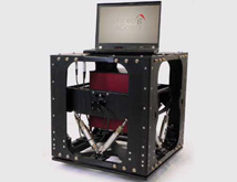
TAGS-6 or GT-2A AIRBORNE GRAVITY METER
Dynamic gravity resolution has improved over the past few years mainly because of improved GPS positioning and the consequent improvements to instrumentation and processing. Under goodconditions, using a TAGS-6 or GT-2A airborne gravity meter, we can achieve a wavelengthresolution of about ninety seconds of flight-time, which corresponds to about 3km at a typical 130-knot (approximately 240 kph, 67 metres/sec.) survey aircraft speed.
TAG 6 DYNAMIC GRAVITY METER
| TARGET | WAVELENGHTS | AMPLITUDE |
| Pediment and siesmic weathering layer thickness, shallow gas pockets, karst | 10 - 200m | 0.05mGal 0.2mGal(200µGal) |
| Shallow salt domes and cap rock | 200 - 1km | 0.1mGal 0.1 - 0.3mGal |
| Anticline, faults, deep salt dome flanks and overhangs | 500m - 2km | 0.2 - 2.0mGal |
| Deep sedimentary basin structures | 2km - 20km | 5.0mGal |
| Sedimentary basin outlines and boundaries, plate tectonic structures | 10km - 100km | 10mGal |