Data Aquisition
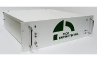
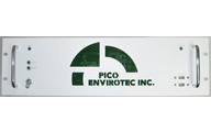
McPHAR’s aircraft and helicopter systems utilize Pico Envirotec’s IMPAC Integrated Multi-Parameter Airborne Console for data acquisition and system control. IMPAC is a NEW real-time data acquisition and navigation system designed for airborne geophysical exploration and environmental science applications. IMPAC combines the field proven technology of Pico Envirotec's AGIS-XP and MMS-4 instruments into a single rack-mountable enclosure. IMPAC has a modular design structure allowing the system to be highly flexible and easily reconfigurable. The modular design allows a wide variety of “intelligent instruments” and third party sensors and instruments to be quickly interfaced. The IMPAC system eliminates the need for much of the normal interconnect wiring between modules.
IMPAC is equipped with sophisticated software allowing easy maintenance and upgrades, and features an integrated digital imaging system, called Geo-iMAGe-Lite, used for digitally recording images of the ground underneath the helicopter’s flight path.
IMPAC also features an integrated navigation system. Any standard GPS system outputting NMEA data strings GPGGA, GPZDA and GPVTG may be interfaced to the system, which provides pilot steering information to the aircraft’s crew to enable them to fly surveys. The navigation package can be pre-programmed with the planned survey grid and drape characteristics, and will guide the pilot and crew for grid flying, waypoint navigation and more. Key acquisition parameters are embedded in the data files for recovery during post-processing.
Key Features:
- Rack-mountable console operating under Windows-XP
- Colour LCD touch screen display and keyboard
- Imbedded MMS-4 magnetometer processor module - selectable sampling rates up to 100Hz
- Imbedded GPS navigation module - provides 2D and 3D navigation capability
- AGRS Advanced Gammaray Spectrometer
- Imbedded Geo-iMAGe-Lite digital imaging system with colour USB camera
- Multiple instrumentation interfaces
- Data recording directly to solid-state hard disk drive
- Multiple USB and serial ports
- Eight 16-bit differential analog inputs channels
- GPS input and 2 PPS outputs
- Multiple Ethernet connections
- Multiple RS232 Serial ports
- Multiple USB ports (2 on front for data transfer)
- 28V DC power input
- Eliminates the need for much of the normal interconnect wiring between modules
MMS-4 Magnetometer Gradiometer Processor Module
The MMS-4 is an intelligent high sensitivity and high resolution (0.2pT) magnetometer/gradiometer processor able to process signals from as many as 4 magnetometers at data rates of up to 100Hz. Signal decoupling, power control, and anti-aliasing filtering is supported. This module, imbedded within IMPAC, is also equipped with an eight channels, 16 bit, +/- 10 VDC, A/D converter that allows data acquisition from analog peripheral devices such as a triaxial fluxgate magnetometer, radar and barometric altimeters, temperature and humidity sensors.
Geo-iMAGe-Lite Digital Imaging Module
The Geo-IMAGE-Lite imbedded module comprises video capture software integrated with the IMPAC data acquisition system and a USB digital colour video camera with a 6mm wide angle lens. JPG images may be captured at user selectable frame rates from 1.0 frame-per-second to 99 seconds-per-frame. The video frames are overlaid with latitude, longitude, line number and fiducial number.
 |
 |
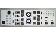 |
| IMPAC Integrated Multi-Parameter Airborne Console. | Front and rear console views of IMPAC. |